
Description
GARMIN Chartplotters – GPSMAP® 943xsv SideVü, ClearVü and Traditional CHIRP Sonar with Mapping
010-02366-61
With its sleek design, powerful processing, and upgraded IPS display, this advanced 9” Chartplotter integrates seamlessly into your Garmin marine system.
Features:
- ULTRA HIGH-DEFINITION SCANNING SONAR – Get built-in Ultra High-Definition SideVü and ClearVü™ scanning sonars with vivid, high-contrast color palettes to help distinguish fish from a structure. GPSMAP® X3 series also supports 1 kW CHIRP traditional sonar capabilities.
- PANOPTIX™ SONAR SUPPORT – Pair with Panoptix or LiveScope™ easy-to-interpret live sonar (transducer required, sold separately) to see all around your boat in real-time.
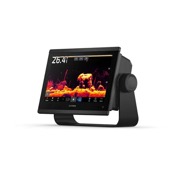
- FASTER, SHARPER, SMARTER – With its added processing power and new slimline design featuring edge-to-edge glass and a smaller unit footprint, it’s easy to retrofit this plotter in a wider range of dash configurations.
- IMPROVED DISPLAY OPTICS – New higher-resolution IPS displays for 9” and 12” plotters offer improved sunlight readability and visibility from any angle, with 50% more pixels than previous-generation 9” GPSMAP devices.
- PRELOADED MAPPING – Experience unparalleled coverage and detail with built-in Garmin Navionics+ integrated coastal and inland mapping1 with Auto Guidance+™ technology3 on select chartplotters.
- OPTIONAL CHARTS AND MAPS – Bring a fresh new look and feel to your chartplotter with optional Garmin Navionics Vision+™ premium charts, featuring high-resolution relief shading, satellite imagery, sonar imagery, and more.
- OPTIONAL RADAR BUNDLE – To help you avoid weather and traffic on the water, the compact 4 kW GMR™ 18 HD+ dome radar is available as a bundled option with your GPSMAP chartplotter/sonar package.
- GARMIN SAILASSIST™ SAILING FEATURES – View laylines, race start line guidance, enhanced wind rose, heading and course-over-ground lines, true wind data fields and tide/current/time slider, wind angle, set and drift, wind speed, polars, and more3.
- SAILING POLARS – Use the polar table to see key data, including how fast you should go at a certain wind angle and speed — so you know whether you need to adjust sail trim.
- GARMIN MARINE NETWORK – If you have multiple compatible Garmin devices on your boat, you can share information — such as maps, user data, radar and IP camera video — among them.
- NMEA 2000® AND NMEA 0183 NETWORKS – Connect to compatible autopilots, digital switching, weather, Fusion-Link™ audio system, media, VHF, AIS and more from one screen.
- ACTIVECAPTAIN® APP – Built-in Wi-Fi® connectivity pairs with the free all-in-one mobile app for access to the OneChart™ feature, smart notifications, software updates, Helm, Garmin Quickdraw™ Community data and more4.
- INTEGRATED ANT® TECHNOLOGY – Connect with some of your favorite devices, such as quatix® marine watches, gWind™ Wireless 2 transducers, GNX™ Wind marine instruments and wireless remote controls.
- ENGINE CONNECTIVITY – Now you can connect your chartplotter to different kinds of engines, including select Yamaha engines.
- ONEHELM FEATURE – This feature brings together all the operations and capabilities of select third-party devices, such as EmpirBus™ digital switching, on one screen.
2 On select models
1 Requires ActiveCaptain app on your compatible smartphone paired to the GPSMAP 943xsv
3 Auto Guidance is for planning purposes only and does not replace safe navigation operations
4 When paired with a compatible smartphone
Wi-Fi is a registered trademark of the Wi-Fi Alliance.
- Worldwide basemap: Non-detailed map for general reference.
- Garmin Navionics+™: Detailed charts for coastal/inland water and lakes.
- Traditional CHIRP: Good for displaying fish arches.
- ClearVü: Excellent for displaying fish and structure below your boat.
- SideVü: Excellent for displaying fish and structure to the sides of your boat.
Specifications for 943 Model
- Display Size: 7.8″ x 4.4″; 9.0″ diagonal (19.9 cm x 11.2 cm; 22.9 cm diagonal)
- Power Input: 10 to 32 Vdc
- Display resolution: 1280 x 720 pixels
- GPS: Yes
- Dimension: 9.2″ x 6.4″ x 3″ (23.3 x 16.2 x 7.6 cm)
- Receiver: 10 Hz
- Waterproof: IPX7
- Weight: 3.6 lbs (1.6 kg)
- Mounting Options: Bail, flush or flat (Garmin does not offer any hardware or accessories for a flat-mount installation. Professional tools and knowledge is required.)
- Display Type: WXGA
In the Box
- GPSMAP 943xsv chartplotter
- microSD™ card preinstalled
- Power cable
- NMEA 2000® T-connector
- NMEA 2000 drop cable (2 meters)
- 8-pin transducer to 12-pin sounder adapter cable
- Bail mount kit with knobs
- Flush mount kit with gasket
- Protective cover
- Trim piece snap covers
- Documentation
With 18 HD+ Radar – Above contents plus:
- GMR 18 HD+ radome
- Mounting hardware kit
- Power cable (15 m)
- Network cable (15 m)
- Installation instructions
- Mounting template
Reviews
There are no reviews yet.